November 27th,
This week we looked at mass wastage events. Most people when they think of mass wastage think of trash, but for the sake of this lab we referred to it as landslides and slope failures. In the lab we looked at landscapes prone to mass wastage events and factors that trigger them.
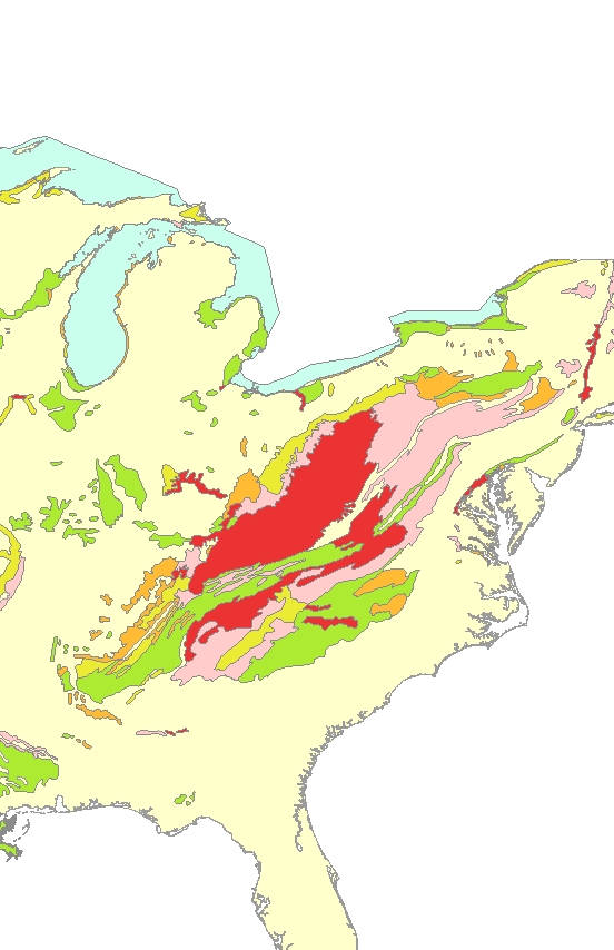
In part 1 of our lab we looked at the Appalachian Mountain range and found that there is a wide array of rock types and terrain all moving in several different directions leading to a less-stable bedrock (i.e. more susceptible to mass watage events). Below is an image of what we were looking at:

Part 2 of our lab analyzed rainfall and elevation by viewing cumulative Doppler Radar data. The Doppler Radar allows one to see motion of precipitation and find out when and where rain will fall. If that rain happens to fall on an area with a higher risk of mas wasting, organizations can help people prepare for it. The image below depicts a large storm that moved through Forest Falls, California in July 11, 1999. The general direction of the storm was moving from the northeast. This is related the potential mass wasting events simply because if there is a higher risk of mass wasting on the northeast side of Forest Falls, the likelihood will increase even more because of the increased amount of rain on that side of the area.

Part 3 of the lab analyzed the aftermath of the large storm that passed through Forest Falls, but more specifically, the mudflows that resulted because of it. If you look at the map below, you will see several parcels of land (color-coded) at a bottom of a valley, which is Forest Falls, CA. As you can see,The danger level of the parcels on the eastside of the area are highly susceptible, because the danger of the level of the slopes in that area are higher than the rest of the slope. This is poor planning altogether simply because the parcels are far too close to the slopes.
We also found that vegetation played a huge role in the mudflow event that came after simply because a large amount of vegetation adds to the weight against the landscape leading to a higher chance of mass wasting. According to the map, there is a large amount of vegetation around the same area of a higher slope danger level which means the parcels will more likely take more damage in the event of a mass wasting event.

The next image shows the amount of rainfall from the storm itself (the darker the color purple, the higher amount of rain). As you can see, the north and southeast sides of the map had the highest amounts of rainfall. This is very much related to the areas with high slopes because these are the areas that are more likely to encounter a mass wasting event.
Finally, we looked at how damage was actually done from the storm. What we found is that the greatest amount of flowage ran straight through the higher amount of parcel damage, however the existing stream does not meet up with the flowage until the end of the parcels.
In addition to the lab, we were asked a series of "critical thinking" questions which I have posted below if you so choose to read them!
Q: What other forms of data could you have used to make components of this lab into a more realistic model. Be sure to explain.
A: Other forms of data that could be used would be an actual damage assessment to the parcels (i.e. how much it had cost to repair the damage).
Q: You examined a post-event analysis to see what went wrong. In terms of using this method to prevent such a disaster, can the GIS help prevent these events in the future? Why or Why not?
A: GIS can do a lot to help prepare for future events. It draws from many different sources is developing a complex paradigm, such as the Doppler Radar, slope danger levels, and ultimately damage from mass wasting events. Giving this knowledge (such as the knowledge of slope risk) to organizations will allow those organizations to prepare areas for future environmental hazards.
Q: What is the role of government/zoning laws when it comes to building in areas at risk for mass wastage? Do you think there are places where people should just not build, or do you think people should build wherever they want? How does the free market and mitigation efforts such as insurance come into this question?
A: I believe that there are certain areas that people should just not build things (like the bottom of a valley or the top of a mountain) and I do believe that the government should give a warning in regards where it is safe (or not safe) to build/develop. However, I also believe in a free market and that people should have the right to build where they wish with keeping certain things in mind; what I mean by this is the government should watch closely and prevent people from building in areas that will either put others at risk or severely damage the environment without any benefits.
As for insurance, people should be responsible for their own actions and if their insurance rates go up because they choose to build in areas of higher risk, that is their own “fault,” for the lack of a better word.