The other day I was watching the evening news (at my mother's house in the Green Bay area) and a news story caught my attention. First of all, over the past half a century a series of small islands (known as the "Cat Islands") in Green Bay (the body of water, not the city) has undergone a slow but steady process of erosion. This is mostly due to rising water levels and severe storms within the bay. Secondly, every year the city of Green Bay must go through dredging, which is the digging of soil at the bottom of a river in order to, in this case, make room for large cargo ships that make their way through the bay and the channel. However, what is left over is a massive amount of soil that either settles into the bay or back into the channel.
The story covered a new project that is currently underway to essentially move all of that soil to the Cat Islands, not only to remove it from the channel, but to possibly re-establish several lost habitats for many species of birds, fish, turtles, amphibians, and invertebrates. This idea is great in theory and it would be fantastic to put the soil to good use. However, what is being ignored (and this was mentioned in the news story) is if the soil being used is actually clean, even though the project directors say it is. This is troublesome, because it is not a completely far-fetched idea that the soil would be dirty; after all, several hundred (if not thousands) of ships (both cargo and non-cargo) make their way through the channel and bay, leaving behind exhaust, oil, and sewage.
The movement of the sediment is scheduled for Summer of 2013.
Here is a link to the presentation all about the project: http://www.portofgreenbay.com/uploadedFiles/Cat%20Island%20Presentation.pdf
Monday, September 24, 2012
Tuesday, September 18, 2012
Wildfires
Once again, in my geography course we tinkered around with some pretty cool software (much like we did the other day with "Stop Disasters"). This week, however, we took a look at some software that actually deals with the "real world" (not that Stop Disasters is not "real world," it just does not depict actual events happening in the real world).
The program we were using this time around was called ArcMap which is Geographic Information System (GIS) that utilizes data collected from a plethora of agencies (both government and private). This data ranges anywhere from reported earthquakes to floods to wildfires; the latter is what perked my interest the most.
As I am sure you have heard, Colorado was recently hit by a series of wildfires from June to July this year. This burned over 200,000 acres of land, more than 600 homes, and resulted in millions of dollars in damage (Wikipedia: http://tinyurl.com/9k7kqqp). One of the causes of the fires was no doubt from extremely dry conditions (from drought the winter before) as well as high temperatures before the wildfires broke out. This history of wildfires interested me, so I decided to do a little research into them.
First, I looked up what wildfires were currently going on the U.S. as of now. I found that, unsurprisingly, the majority of wildfires (at least of now) are occurring in the Northwestern U.S.; no longer in Colorado, but in Utah, Wyoming, and especially Idaho (as seen by the map below).

Taking into account how the Colorado fires took place, I decided to also look into past reports of drought as well as rainfall in that area over the past few months. What I found was what I expected. Over the past few months (from June to forecasts going into October), it has been quite dry in many areas where wildfires are currently active (as seen by the maps below: June to August on the left and August to October on the right):


I am sure this is not really any shock to some well-versed meteorologist, but I just found it interested. I hope you did as well!
Friday, September 14, 2012
Stop Disasters...seriously, stop them.
So, in my Geography 361 class we were tasked with playing an online game called "Stop Disasters." It is a small game, funded by the ISDR (International Strategy for Disaster Reduction) in which the object is to "save lives" by building defenses, warning systems, better housing in a pre-set community where a natural disaster is about to hit.
On a side note, the ISDR is a collaborative group of colleges, organizations, and institutions with the goal of "reducing the number of dead and injured by disasters triggered by natural hazards." They analyze steps that can be taken in order to reduce or remove the impact of a natural hazard; they use the Stop Disasters game to promote awareness of the impact of natural disasters, as well as educate people on what precautions can and should be taken to do so.
Okay, back to the game. In my class we were to play the "tsunami" scenario where, as you may guess, we are to protect a little town along the coast of I-Shouldn't-Have-Built-My-Village-On-The-Coastville (which is somewhere in Southeast Asia).
 As you can see above, one of my main strategies was to build most of the residential (the concrete houses and hotels) on the high ground. The high ground provided a natural barrier simply because it was above the highest point of the tsunami (15 meters); I did not know the initial height, but I assumed the high ground would be high enough (which it was!).
 Secondly, as shown above, I focused on providing protection the main disaster shelters (the school, hospital, and community center) as well as building warning devices on in the community center to warn as many people in advance; you can build deep-sea seismic sensors which can serve as an early warning device (approximately 4 hours) for people, which can save many lives.
Overall, I believe I did a pretty good job. Only 22 people died and 22 were injured; I wish the total casualties was a bit lower, however. I forgot to build up the defenses on a few of the small (brown) hotel-huts and log huts and I believe that led to those casualties. You can take a look at the "new post" the end of the game shows if you wish:
Secondly, as shown above, I focused on providing protection the main disaster shelters (the school, hospital, and community center) as well as building warning devices on in the community center to warn as many people in advance; you can build deep-sea seismic sensors which can serve as an early warning device (approximately 4 hours) for people, which can save many lives.
Overall, I believe I did a pretty good job. Only 22 people died and 22 were injured; I wish the total casualties was a bit lower, however. I forgot to build up the defenses on a few of the small (brown) hotel-huts and log huts and I believe that led to those casualties. You can take a look at the "new post" the end of the game shows if you wish:
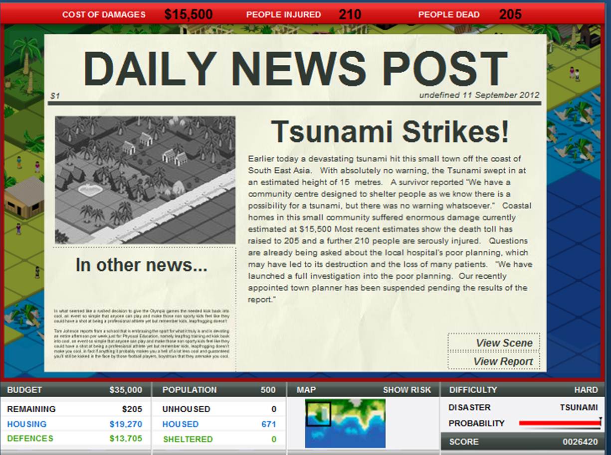
 Next, however, was the fun part. We were "tasked" with doing a horrible job at protecting the town and see how much damage could be done. Challenge accepted. So, as instructed (and as you can see below) I did a great job at doing a horrible job. It is hard to read, but the end results showed a 15 meter tsunami decimating the small town of 671 people; 205 died and 210 were seriously injured with $15,000 in damages.
 The news report even states: "We have launched a full investigation into the poor planning. Our recently appointed town planner has been suspended pending the results of the report." Mission accomplished.
 In all seriousness, though, this is no laughing matter. In the game, one tourist asks, "Hey! Why don't you build the hotels on the shoreline? That would be sweet!" The sad fact is that this situation is very common for most tsunamis is actually what happens in most tsunamis. The people (tourists) want to have the best view of the ocean and hotels are right along the water, which is all well and good. That is, until a tsunami (like the one in 2011) hits and devastates an entire city. In my little game, only 205 people died and 210 were injured. However, in 2011 15,867 people died, 6,109 were injured, and 2,909 were missing, which is a far more serious issue than a video game.
 The main point of this game, I believe, is to educate and inform people on what can and should be done to help prevent disasters. In my opinion many villages should not be where they are (preparations should not be made to protect a certain area if that area is constantly in danger of a natural hazard. This includes places like I-Shouldn't-Have-Built-My-Village-On-The-Coastville and real-world places like New Orleans. Both of these places are in a hot spot to experience devastation and it costs billions of dollars to keep them afloat...pun intended.


Thursday, September 6, 2012
Subscribe to:
Posts (Atom)